


Glacier Lodge and Glacier Viewpoint Trail (10/14/2005)
I left Bishop quite early in the morning, with the intention of only "swinging by" to see Glacier Lodge and take a few photos of the Glacier from the lodge, and then check out other points of interest on the way to Lone Pine for the night. That plan got derailed at my first destination.
Finding the road to Glacier Lodge was not easy. I had expected to see big road signs of the Glacier Lodge Road, but missed whatever sign there could be twice.After going past Big Pine without seeing the road sign, I had to turn back and asked a gas station attendant for direction. I believe the road to take is Crocker, which winds up the mountain to Glacier Lodge. There are two gas stations on both sides of the turn.
 After
a scenic drive on a windy but easy road up the canyon, I reached Glacier
Lodge.Next to a roadside picnic area, I found a nice setting of a bridge
crossing Big Pine Creek, lined by cottonwood and willow at various stages
of peaking. After taking a few snapshot of this "common" picturesque spot
[among places I'd been to in prior days], I wandered around before heading
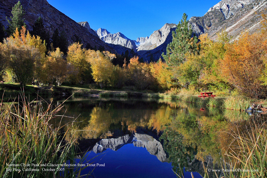
down the canyon road. Then I stumbled on a beautiful pond with clear and
crisp reflection of the yellow/golden trees, surrounding mountains and
the deep blue sky. This made me stay longer through the early morning
light to capture different mood of the reflecting pond. I was the lone
soul at this pond for quite some time, and the air was cold, evident by
the frost on the grass and tree leaves. The sky was deep blue clear, and
there was no sound. Even my footsteps were muffled by the damp grass.
The big sign of "Trout Pond" on the side of the road explained the occasional
water ripples caused by some fish going to the surface to catch breakfast.
I could not help but taking many pictures at this location with various
compositions as the light intensity increased with the sunlight reflecting
higher on the mountainside. This was one occasion when I found my ability
to capture the moment on film to be limited. Even so, there were a few
that I liked enough to post. I even caught the moment of a trout leaping
out of water to catch a bug, I presume. Unfortunately, with the early
morning low light and the slow shutter speed to increase depth of field,
the image of the trout was blurry. I promised myself to return to this
spot another time to see whether I would experience the same feeling of
astonishment and awe of nature beauty.
After
a scenic drive on a windy but easy road up the canyon, I reached Glacier
Lodge.Next to a roadside picnic area, I found a nice setting of a bridge
crossing Big Pine Creek, lined by cottonwood and willow at various stages
of peaking. After taking a few snapshot of this "common" picturesque spot
[among places I'd been to in prior days], I wandered around before heading
down the canyon road. Then I stumbled on a beautiful pond with clear and
crisp reflection of the yellow/golden trees, surrounding mountains and
the deep blue sky. This made me stay longer through the early morning
light to capture different mood of the reflecting pond. I was the lone
soul at this pond for quite some time, and the air was cold, evident by
the frost on the grass and tree leaves. The sky was deep blue clear, and
there was no sound. Even my footsteps were muffled by the damp grass.
The big sign of "Trout Pond" on the side of the road explained the occasional
water ripples caused by some fish going to the surface to catch breakfast.
I could not help but taking many pictures at this location with various
compositions as the light intensity increased with the sunlight reflecting
higher on the mountainside. This was one occasion when I found my ability
to capture the moment on film to be limited. Even so, there were a few
that I liked enough to post. I even caught the moment of a trout leaping
out of water to catch a bug, I presume. Unfortunately, with the early
morning low light and the slow shutter speed to increase depth of field,
the image of the trout was blurry. I promised myself to return to this
spot another time to see whether I would experience the same feeling of
astonishment and awe of nature beauty.
Just about the time I reluctantly packed up to leave, an older gentleman dropped by and pointed out to me that I had been taking pictures of Norman Clyde Peak . He also told me that I had not been seeing the Glacier. That disappointed me because I thought I had been taking picture of the Palisade Glacier. As we conversed, he told me about the trail that would take 3-4 hours for a fast hiker to get to a lookout point, to which I commented that I did not have the time to take that trail since I had to get on my way soon to keep my day plan. After saying goodbye to the man, I decided to pack some light snacks and 3 little juice packs for a short stroll on this trail hoping to find other magical spots like the pond. I packed another light jacket just in case it would get cold, and therefore did not have room for more water or food in the makeshift foodpack. All of these turned out to be wrong as you'll see below!
 With
no more knowledge of the trail than the brief verbal description from
the old man, I started on the picturesque and peaceful trail for an hour
stroll. A creek bordered the trail for much of the way. At that time of
the year, it was also colored yellow, red, green and gold by trees at
different stages of peaking. The beauty of the scenery along the trail
such as leaf colors, waterfalls, crisp morning air and natural silence
drew me deeper and higher into the trail. I found the urge to go on just
a little more all the time. As the hour approached, and while snapping
one picture after another, two ladies - Ellen and Jeanette caught up with
me on their hike. We struck a conversation about the beauty of the scenery,
and said goodbye as I continued with picture taking and they moved on
to the next leg of the hike. This sequence repeated itself multiple times
as somehow I always managed to catch up with them after my picture-taking
side trips. I suppose they also took their time for conversations and
sightseeing. This encounter eventually turned out to be a blessing for
me since they were well prepared for the hike both with maps and food
supply. Hours later, as I was about to give up the hike, I caught up with
them again and was told how close I was to the glacier viewpoint. Knowing
I was close and there were trail companions, I pushed on for another hour
to reach the lakes and the view of the glaciers. On the way back, they
insisted on my taking some snacks and a bottle of water. That really helped
because I had been conserving the last juice pack for really needy time.
It was not wise to drink just 2 packs of juice on that 4-hour climb, even
though the cool weather helped to some degree.
With
no more knowledge of the trail than the brief verbal description from
the old man, I started on the picturesque and peaceful trail for an hour
stroll. A creek bordered the trail for much of the way. At that time of
the year, it was also colored yellow, red, green and gold by trees at
different stages of peaking. The beauty of the scenery along the trail
such as leaf colors, waterfalls, crisp morning air and natural silence
drew me deeper and higher into the trail. I found the urge to go on just
a little more all the time. As the hour approached, and while snapping
one picture after another, two ladies - Ellen and Jeanette caught up with
me on their hike. We struck a conversation about the beauty of the scenery,
and said goodbye as I continued with picture taking and they moved on
to the next leg of the hike. This sequence repeated itself multiple times
as somehow I always managed to catch up with them after my picture-taking
side trips. I suppose they also took their time for conversations and
sightseeing. This encounter eventually turned out to be a blessing for
me since they were well prepared for the hike both with maps and food
supply. Hours later, as I was about to give up the hike, I caught up with
them again and was told how close I was to the glacier viewpoint. Knowing
I was close and there were trail companions, I pushed on for another hour
to reach the lakes and the view of the glaciers. On the way back, they
insisted on my taking some snacks and a bottle of water. That really helped
because I had been conserving the last juice pack for really needy time.
It was not wise to drink just 2 packs of juice on that 4-hour climb, even
though the cool weather helped to some degree.
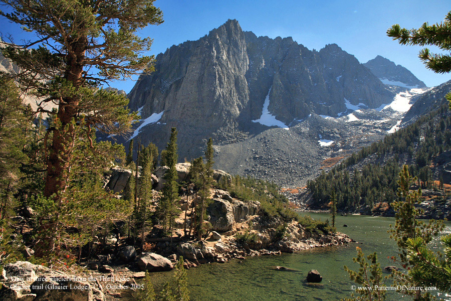
I don't know what caused me to continue the journey up that trail as I found myself exhausted half-way up with my food/water supply depleting. Perhaps it was the stubbornness against giving up, or just the desire to see the Southernmost Glacier in the US- Somehow, I was always drawn to the "most" of something. So far this year, I've been to the lowest point in the US in Death Valley , viewing the southernmost glacier and the highest peak in the continental US, among others. Anyhow, the worst thing was that I did not even know how far I was to where I needed to be to see the Glacier, or where that viewpoint was. This trail turned out to be more complicated than my expectation of a single path winding uphill. There were several trails going in separate directions for different purposes. For example, the trail names of North Fork and South Fork probably give you an idea of how diverse the paths could lead. My stubbornness kept me going on with the more difficult trail - steeper ones, and much longer than I should have. There was a pointof my exhaustion when I decided to count to 2000, and would turn back after that (which I broke). I found out something about myself that I should watch out for - the tendency to keep pushing into the unknowns without adequate preparation, and took more risk than I should. It was hilarious and alarming that I made the same mistake again the following day as I visited Whitney Portal- More on that later. In any event, I need to watch out for this when I decide to go back to the business world. Ultimately, I did reach the third lake where the view of the glaciers was quite good, although the lighting condition against the early afternoon sun was not conducive for artistic photos - at least I'd use that excuse. These alpine lakes were beautiful. They were surrounded by majestic mountains, giant rock boulders and pine trees right down to the water line. The water has a turquoise hue due to the water runoff from Palisade Glacier. After a short half hour staying a the third lake to recooperate some strenth, I headed down the trail to truly continue with my trip to Lone Pine. The downhill hike was thankfully less interesting. I only had to watch for the cloud coming in that could change the temperature and hiking condition quickly and dramatically at that elevation.
The short one-hour stroll near the start of the trail became an 11-mile roundtrip with about 2800' gain to 10400' elevation. By the time I reached my car, I had spent some 7 hours on this trail. Despite my poor planning and execution, I was happy and exhilarated for having made that trip, reached a difficult goal and expanded my view. As a bonus, I also made two new friends.
Time to hurry on to Lone Pine and skip all other destinations I had considered visiting. Next time, plan better.
Oh, the pictures are posted HERE.
Home About Us Friends Family Copyright
Last updated: October 17, 2010